Tuesday 26 March 2024

HOMES NOT ROADS

Dyers Hall Road, 26th March 1994
Revisiting my photographs of the M11 Link Road demolitions of 1993-94, I do find myself wondering why I didn't take more pictures. I had an awareness that I was documenting something and yet I wasn't at all systematic, and didn't think to keep notes about the photographs I was taking, which means that some pictures are very hard to locate, especially given the homogeneity of the terraced houses along the route. On 26th March 1994, which was a Satruday, I went out after lunch to go to the National Gallery (there was an exhibition of Claude Lorrain's work, including drawings); on my way, and got off the Central Line, to walk between Leytonstone and Leyton stations again. I took just eight photographs on colour film, many going back to houses I had photographed on black and white film taken earlier, but also took a couple on Grove Green Road, which (unless mistaken) I had not documented previously.

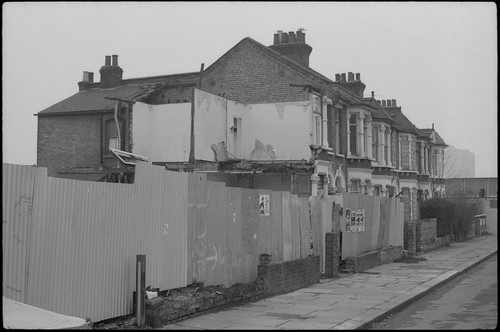
The first frame was of an industrial building on Grove Green Road, close to Leytonstone Station. On a map from 1950, this is marked 'printing works'. Looking back, I find I have no memory of what it was like to exit Leytonstone Station then, something I didn't think to photograph. Just past this short section of Grove Green Road outside the station, Church Lane ran underneath the railway to join up with the high street, something I don't remember; there is now a playground on the open space of the junction. Placing the first photograph from 26th March 1994, I relied on Tim Brown's photographs on Flickr: this particular building appears in a photograph (taken three days after I was there) alongside C&M Apostolides Ltd, which has a clear road number on its sign, locating the building in my photograph securely. I didn't know about Tim Brown's pictures in 2014 when I returned to revisit my images; the photograph below, taken on Grove Green Road in 2014 is very broadly in the same area, but not exactly the same view.


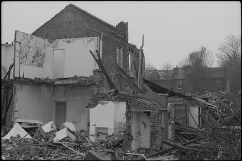
The next photographs are on Dyers Hall Road, where I took many of my pictures. There are three photographs of the house on the corner which I had first photographed on 31st December, then in the process of being demolished, rather more easy to replicate in 2014.


In my photograph from December 1993 of this particular house, one can see a blue plaque on the house (see Retracings), reading 'Our heritage–this house was once a home', an artwork by Paul Noble. This was evidently retrieved from the demolition: it appears in Fieldstudy No.9, and is listed there as being in the Museum of London.


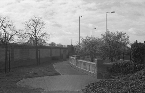
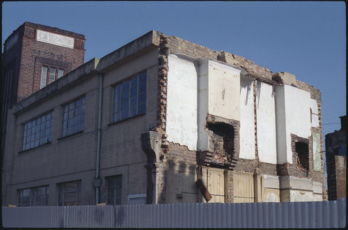
The next two photographs, one appearing at the head of this post, show a house on Dyers Hall Road that I had photographed on 18th February (see Photographs Not Taken), the end surviving building on the row backing onto the Central Line before the footbridge. The contemporary view simply shows the brick wall running alongside the A12.


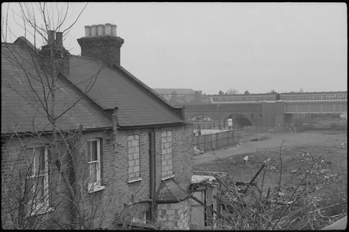
There's a second photograph from Grove Green Road, after Dyers Hall Road rejoins it. This is a garage, which in 2014 I couldn't really place: the buildings on this side of Grove Green Road were demolished, but enough space remained after the road was built to create a long and narrow park, fittingly called the Linear Park. In 2014 there was a wall and railings separating the park from the road, which have now been removed and a cycle lane installed alongside the pavement that runs along it. I took a few photographs at different positions: not clear which might be the right one, I chose one with trees in blossom to stand in for the unknown precise location.


The last photograph is hard to place, a detail of a doorway of a demolished house. It could conceiveably have been on the section of Grove Green Road which is now the Linear Park, but I think it's more likely to be on Colville Road, possibly close to the Langthorne Road bridge, now a foot and cycle bridge. The 2014 photograph is again that of the brick wall along the A12 (the top of the footbridge can just be seen above the wall to the right).


The eight photographs taken on 26th March 1994 were the last I took for a number of months; this was at the start of the Easter holiday, so I wasn't travelling past the route of the road on the Central Line everyday, seeing the progression of the houses being demolished; shortly after being back at college for the summer term, my camera, a Praktica BC1 jammed. I was quoted £60 to send it away to be looked at without a guarantee that it could be fixed. It had cost £50 secondhand, a Christmas present, and so I was without a camera for a number of weeks until I found a Praktica BCA body for £26 to replace the body of the BC1 (the Bank of England inflation calculator shows these prices to be just double that today).

Monday 18 March 2024

'WELCOME TO ESSEX'

Grove Green Road, 18th March 1994
Growing up in Ilford in the 1980s and 90s, its identity as being part of London was somewhat ambivalent: ‘London’ for me was something that happened after you got on the tube (and passed the destruction along the Central Line as the houses in Leytonstone were being demolished). Ilford had been part of the new London Borough of Redbridge established in 1965, but retained an Essex postcode, and in some respects it felt as though it faced out towards Essex along Eastern Avenue (to which the M11 Link Road would join as part of the approach to the Redbridge Roundabout) as much as into London in the other direction, and the quality of being on the edge of the urban sprawl was very evident: one had to only go to a number of stations on the Newbury Park loop of the Central Line to find the point at which the march of bricks and mortar were halted by the green belt. Despite being born in central London, and spending most of my childhood and adolescence in a London Borough, it was only leaving to study for my degree when I was defined (by others) as a ‘Londoner’.

The poster in the image above from which this post takes its name was advertising the album Essex by Alison Moyet, released the Monday after the day I took these photographs (as was the Deacon Blue single), named for the singer’s native county. Of the other music postered to the corrugated iron fence, Carter the Unstoppable Sex Machine had been popular among a certain section of the sixth form I’d recently left; the Soul Asylum record had been out for well over a year by the point I took the photograph, but possibly was being promoted after the single Runaway Train had won ‘Best Rock Song’ in the Grammys earlier that month. This arbitrary selection of posters might in some way indicate popular music at that point early in 1994: ‘Britpop’–however defined–hadn’t quite made itself felt culturally at that point; Parklife was released at the end of April, a few weeks after these photographs were taken.

On 18th March 1994, as on previous occasions,  I walked between Leytonstone and Leyton stations to take photographs along the route of the M11 Link Road. It had been a whole month since the last photographs, and I was aware that more buildings had gone in the weeks since, but I took less pictures, just nine frames, before getting back onto the Central Line and going to visit the Sir John Soane's Museum (where I took quite a few photographs), and the British Museum to see an exhibition on Victorian illustrated books, and bumped into someone I knew from school drawing from the Parthenon sculptures. I took no photographs on Dyers Hall Road, where I taken numerous pictures a month before. Instead, the sequence begins on Grove Green Road with two very similar photographs; this section of Grove Green Road became the Linear Park. In 2014, when I revisited the locations to take photographs twenty years on, the Linear Park had railings along the road–which have subsequently been removed.


I can't quite be sure that the photographs from 2014 were really in the right place–the facing terraced houses seen at the right of the bottom pair of images does provide some orientation, but the Linear Park represents quite a long stretch of road where numerous buildings–not just houses–were demolished. The weather on 18th March 1994 was similar to that of 18th February, the previous date I took a series of photographs, heavily overcast, although less misty. In 2014, it was sunny, and photographing into the light for a number of shots, the Prakticar f1.8 lens imparted some haze to many of these images.

The picture at the head of this post is the corner where the northern end of Claremont Road met Grove Green Road and used to feature a short parade of shops. That there is a billboard on the side of the house above the remains of number 153 on the corner suggests that this house had been demolished some time previously. The end of this terrace was pulled down to number 143; two newer houses were built adjoining 143 after the completion of the road, which can be seen in the picture from 2014, below. This end of Claremont Road has completely disappeared, making for a generous width of pavement and a more gentle angle for Grove Green Road to meet the rebuilt Cathall Road bridge, to the left of the picture below.


I took one photograph on Claremont Road itself, replicating a colour photograph taken in January at the southern end of the terrace facing the railway line; the remaining stub of this end of Claremont Road provides the opportunity to take a similar photograph, but in reality this should be shot from a position hovering over the A12.


The rest of the photographs were taken on Colville Road, some made standing on the remnants of garden walls to look over the fences, possibly reinstated from when I'd taken photographs a month before and had found a number of them torn down, and took some pictures from behind the fences. In the pair of images below, the picture from 2014 is too far to the left: the line of Colville Road was moved, and as a result the corner from 1994 would be under the current wall alongside the A12. 


As with a number of my other photographs, replicating the views in 2014 (and today) results in pictures of this brick wall, with little else to enliven the compositions. Many of the mature plane trees on the far side of the railway are still recognisably the same trees however, providing one point of reference when rephotographing.


The last two photographs from the 18th March were taken at the far end of Colville Road. Here, Langthorne Road crossed over the railway. Now a foot and cycle bridge, before the building of the A12 this was a road bridge, a presumably a cut through from Grove Green Road to the other side of the railway avoiding the high road. Langthorne Road has almost disappeared, the section that joined Grove Green Road being pedestrianised; in a similar fashion, at the other end of this stretch between the two Underground stations, Church Lane used to join Grove Green Road under the railway from the other side of Leytonstone Station. Now a a dead end road on the other side of the Central Line, Church Lane's junction with Grove Green became a playground and an approach to the footbridge which took its place. 


Sunday 18 February 2024

Photographs Not Taken


Colville Road, 18th February 1994
Continuing my project of documenting the demolitions to make way for the M11 Link Road in 1994, I had gone to take more photographs on the 13th of February, a Sunday, essentially retracing my steps from a month earlier (see SQUIBB) when I’d used colour film, walking between Leytonstone and Leyton stations, then getting the tube back to Leytonstone–rather than Wanstead–and walking from there to Wanstead Station. It was bitterly cold, presaging a couple of days of snow, and, given the police and security activity around George Green in Wanstead, I’m not sure I tried to take many photographs there: as it turned out, I hadn’t loaded my camera properly. When rewinding the film later in the week, I realised my mistake (I don’t think I knew then to keep an eye on the rewind crank turning as the film advanced): the perforations at the very end of the film were torn, and I got the photography technician at college to retrieve the end from the cassette to be able to use the unexposed film (I had at least realised before the possibility of giving myself the additional disappointment of processing the film only to discover that it was blank).

At college, I found myself not knowing what kind of work to make. Conversations with the course tutors–one in particular–suggested that I should concentrate on painting and drawing from observation, this being seen as where my strengths lay. The course itself, however, was opening up possibilities, different ways to think about and to make artwork. Learning photography and using my first SLR camera began a turn away from making work by hand direct from the motif, although I was still doing some work like that. Having spent the previous summer filling a sketchbook with observational drawing, the camera had begun to supplant my sketchbook. Something which had had an impact at the time was seeing the American Art in the 20th Century exhibition at the Royal Academy in the autumn. I’d started making a number of Rauschenberg-inspired collages, which combined some of my photographs–including those from the M11 Link Road–with clippings from magazines, leaflets, and studio detritus. There was a lack of confidence in what I was doing though: I realised that everything that had been highly prized when studying A-level art was now no longer that important. Different values were in play. Concurrently, around this time I was beginning to attend some open days for degree courses, and, although the work I had been making was changing, I was still set then on studying painting (I subsequently failed to secure a place on a painting degree course, studying printmaking instead).

I returned with the same film in my camera on Friday the 18th February, and walked between Leytonstone and Leyton stations again, without returning to Wanstead; later that day I drew a schematic map of the route in my diary. The day before, I had a surprise in seeing a friend from school (who was still at school at the time) on the cover of the G2 section of the Guardian, in the middle of a crowd that had been on the Green the previous day, which must have been around the time of the evictions from the treehouse in the ancient chestnut tree there, its occupation an attempt to prevent the tree being cut down. Between Leytonstone and Leyton some of the houses had been demolished during the week since I’d failed to photograph them. Looking back, it’s interesting to note that many of my photographs of the route were taken on Dyers Hall Road, and on Colville Road, rather than on Claremont Road, the name of which became practically synonymous with the M11 Link Road protest. This may have been due to the fact the houses here were being actively demolished through the winter, while Claremont Road, as the focus of resistance to the road scheme, with the houses there occupied around the clock, was not substantially demolished until much later in the year–and all the houses on Claremont Road were marked for demolition, unlike Dyers Hall Road and Colville Road, both of which partially survived the road scheme. As a result, I seem to recall that Dyers Hall Road in particular had an eerie, deserted feeling. The misty weather on the 18th February when I took the photographs then only added to this.

The sequence of photographs begins on Dyers Hall Road, and unlike the previous occasions, this time I did take many more photographs of the same subjects in some cases, from different angles, moving closer and around the houses, aided by the fact that some of the corrugated iron fences had been torn down during the week on Colville Road, while I stood on some of the remaining garden walls on Dyers Hall Road, to achieve photographs like that below.


When I returned to photograph these locations in 2014, those photographs taken beyond the line of the fences from 1994 were impossible to recreate as these would be entirely within the cutting of the A12 road (the negatives from 2014 were somewhat dense and scanned less well that the thirty-year-old negatives from 1994). 

In many cases, these were just photographs of the wall that runs alongside the A12. In the image immediately above, looking over the wall to the road was perhaps closer to the photograph from 1994 that precedes it; below, when trying to match the railway bridge in the background to the photograph taken in 1994, which really should be more wall and less sky, it provided a nearly abstract composition.

I again climbed the footbridge from Dyers Hall Road over the Central Line, to take a couple more photographs there, the second catching a North London Line train. One more house there had been demolished since the photographs made a month earlier. 


There were just two photographs taken on Claremont Road that day, where the partially demolished houses on the southern dog-leg of the road that I’d photographed in January were now gone. I attempted to recreate the viewpoint of these in two of the photographs taken in 2014, with the result of one being almost entirely the blank wall of the new houses built since (the viewpoint itself was almost certainly further back, hovering over the A12: the advertising hoarding on the side of the house in the background at the left of the frame gives an indication of this).


The rest of the photographs were taken on Colville Road, some revisiting where I'd taken some of photographs in January and in December 1993. The photograph below looks across the northern end of Colville Road, with the backs of houses seen beyond the fence facing onto the southern end of Claremont Road. In the image below this, the gable end of some of the new houses on Claremont Road appear beyond the buddleia, probably more to the left of the position in the photo from 1994.


The two houses at the end of the road which had been intact in December when I’d taken photographs then had their roofs and side walls removed to make them uninhabitable, ahead of a more comprehensive demolition, an efficient strategy used throughout the link road clearances.


With some of the fences here having been pulled down during the week, I could take photographs from the fields of rubble where the terraces had been sliced through to the gaping insides of some of the houses, backing onto the railway line here in the last couple of photographs (as in the image at the head of this post), only some of which I could recreate in 2014, and many where the angle isn't quite right: in the pair below, the image from 2014 should really show more of the surviving terrace on Colville Road, seen on the right, but should be from just over the other side of the wall.


When I retraced the route in 2014, I took a few additional photographs, not recreating those from 1994, but showing a little of the wider context, something I occasionally feel that I wished had done then, looking back down Colville Road from the footbridge at its end (which used to be a road bridge, although I don't really remember it as such), then, from the far side of the bridge, looking back towards Colville Road, where once the view would have shown the rear of the terraced houses backing onto the railway line, now long gone.